| Algiers Province ولاية الجزائر | |
|---|---|
| — Province — | |
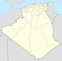
| Map of Algeria highlighting Algiers | |
| Coordinates: 36°42′N 3°13′ECoordinates: 36°42′N 3°13′E | |
| Country | |
| Capital | Algiers |
| Government | |
| • PPA president | Mr. Mohamed Zaïm (FLN) |
| • Wāli | Mr. Mohamed Kebir Addou |
| Area | |
| • Total | 273 km2 (105 sq mi) |
| Population (2008)[1] | |
| • Total | 2,947,461 |
| • Density | 11,000/km2 (28,000/sq mi) |
| Time zone | CET (UTC+01) |
| Area Code | +213 (0) 21 |
| ISO 3166 code | DZ-16 |
| Districts | 13 |
| Municipalities | 57 |
Algiers (Arabic: الجزائر, al-Jazā’ir; Algerian Arabic: دزاير,Berber: Dzayer / ⴷⵣⴰⵢⴻⵔ) is the capital and largest city of Algeria. According to the 1998 census, the population of the city proper was 1,519,570 and that of the urban agglomeration was 2,135,630.[1] In 2009, the population was about 3,500,000. An estimate puts the population at about 3,574,000 as of 2010.[2]
Called El-Behdja (البهجة) or alternatively Alger la Blanche("Algiers the White") for the glistening white of its buildings as seen rising up from the sea, Algiers is situated on the west side of a bay of theMediterranean Sea. The modern part of the city is built on the level ground by the seashore; the old part, the ancient city of the deys, climbs the steep hill behind the modern town and is crowned by the casbah or citadel, 122 metres (400 ft) above the sea. The casbah and the two quays form a triangle.
Etymology
The city name is derived (via French Alger and Catalan Alger[3]) from the Arabic name الجزائر al-Jazā’ir, which translates as "The Islands", referring to the four islands which lay off the city's coast until becoming part of the mainland in 1525. Al-Jazā’ir is itself a truncated form of the city's older name جزائر بني مازغان Jazā’ir Banī Mazghannā, "The Islands of theSons of Mazghanna", used by early medieval geographers such as al-Idrisi and Yaqut al-Hamawi.
History
A Phoenician commercial outpost called Ikosim which later developed into a small Romantown called Icosium existed on what is now the marine quarter of the city. The rue de la Marine follows the lines of what used to be a Roman street. Roman cemeteries existed near Bab-el-Oued and Bab Azoun. The city was given Latin rights by Vespasian. Thebishops of Icosium are mentioned as late as the 5th century.
The present-day city was founded in 944 byBologhine ibn Ziri, the founder of the BerberZirid–Sanhaja dynasty. He had earlier (935) built his own house and a Sanhaja center at Ashir, just south of Algirs. Although his Zirid dynasty was overthrown by Roger II of Sicilyin 1148, the Zirids had already lost control of Algiers to their cousins the Hammadids in 1014.[4] The city was wrested from the Hammadids by the Almohades in 1159, and in the 13th century came under the dominion of the Ziyanid sultans of Tlemcen. Nominally part of the sultanate of Tlemcen, Algiers had a large measure of independence under amirsof its own due to Oran being the chief seaport of the Ziyanids.
As early as 1302 the islet of Peñón in front of Algiers harbour had been occupied by Spaniards. Thereafter, a considerable amount of trade began to flow between Algiers andSpain. However, Algiers continued to be of comparatively little importance until after the expulsion of the Moors from Spain, many of whom sought asylum in the city. In 1510, following their occupation of Oran and other towns on the coast of Africa, the Spaniards fortified the islet of Peñon and imposed a levy intended to suppress corsair activity.
Local architecture
There are many public buildings of interest, including the whole Kasbahquarter, Martyrs Square (Sahat ech-Chouhada ساحة الشهداء), the government offices (formerly the Britishconsulate), the "Grand", "New", and Ketchaoua Mosques, the Roman Catholiccathedral of Notre Dame d'Afrique, the Bardo Museum (a former Turkish mansion), the oldBibliothèque Nationale d'Alger—a Turkishpalace built in 1799–1800—and the new National Library, built in a style reminiscent of the British Library.
The main building in the Kasbah was begun in 1516 on the site of an older building, and served as the palace of the deys until the French conquest. A road has been cut through the centre of the building, the mosque turned into barracks, and the hall of audience allowed to fall into ruin. There still remain aminaret and some marble arches and columns. Traces exist of the vaults in which were stored the treasures of the dey.
The Great Mosque (Jamaa-el-Kebir الجامع الكبير) is the oldest mosque in Algiers. It was first built by Yusuf ibn Tashfin, but reconstructed many times. The pulpit (minbar منبر) bears an inscription showing that the building existed in 1097. The minaret was built by the sultan ofTlemcen, in 1324. The interior of the mosque is square and is divided into aisles by columns joined by Moorish arches.
The New Mosque (Jamaa-el-Jedid الجامع الجديد), dating from the 17th century, is in the form of a Greek cross, surmounted by a large white cupola, with four small cupolas at the corners. The minaret is 27 metres (89 ft) high. The interior resembles that of the Grand Mosque.
Monuments
- Notre Dame d'Afrique , accessible by one cable car, is one of the city's most outstanding monuments: located in the district of Z' will ghara, the basilica was built around 1858.
- Monument des Martyrs ( Maquam E' chahid ): an iconic concrete monument commemorating the Algerian war for independence. The monument was opened in 1982 on the 20th anniversary of Algeria's independence. It is fashioned in the shape of three standing palm leaves which shelter the "Eternal Flame" beneath. At the edge of each palm leaf stands a statue of a soldier, each representing a stage of Algeria's struggle.
- The El Jedid mosqueat the Place des Martyrs near the port.
- Place of the Emir Abdelkader (formerly Bugeaud): in memory of the famous emir Abd El-Kader, resistant during French conquest of Algeria.
- Grand Post Office (1910, by Voinot and Tondoire): construction of the neo-Moorish type which is in full centre town of Algiers.
- The Jardin d'essai (Garden of Test; El-Hamma): situated in the east of Algiers, it extends over 80 hectares (198 acres) and contains exotic plants and gardens. It was created in 1832 by A. Hardy.
- Villa Abd-el-Hair , with the top of the Garden of test, one of the old residences of the dey, where until 1962, were placed the artists prizes winner of Price Abd-el-Hair, and in particular Maurice Boitel and Andre Hamburg.
- Citadel .
- Riadh El-Feth (shopping centre and art gallery).
- Ketchaoua Mosque (This mosque became the Saint-Philippe cathedral during colonization before becoming again a mosque).
- National Library , is in the district of El HAMMA. Architecture modèrne.
- The Great Mosque of Algiers at the Rue de la Marine. It is the oldest mosque of Algiers and was built during the reign of the Almoravid sultan Yusuf ibn Tashfin.
Tourist installations
Some 20 km (12 mi) to the west of Algiers are such seaside resorts as Sidi Fredj (ex-Sidi Ferruch), Palm Beach, Douaouda,Zéralda, and the Club of the Pines (residence of State); there are tourist complexes, Algerian and other restaurants, souvenir shops, supervised beaches, and other amenities. The city is also equipped with important hotel complexes such as the hotel Hilton, El-Aurassi or El Djazair. Algiers also has the first water park in the country. Thetourism of Algiers is growing but is not as developed as that of the larger cities in Morocco or Tunisia.[edit]Public transport
- ETUSA (urban and suburban bus transportation for Algiers) operates bus service in Algiers and the surrounding suburbs. 54 lines are currently operating, with service from 5:30 a.m. to 12:45 a.m.
- SNTF (national railroad company) operates commuter-rail lines connecting the capital to the surrounding suburbs.
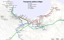
- Algiers Metro, opened November 1, 2011.
- Algiers tramway, opened on May 8, 2011.
- Houari Boumediene Airport is located 20 km (12 mi) from the city. The airport serves domestics, many European cities, West Africa, the Middle East, Asia and North America. On July 5, 2006, a new international air terminal was opened for service. The terminal is managed by Aéroports de Paris.
4 urban ropeways:- El Madania – Belouizdad
- Notre Dame d’Afrique – Bologhine
- Memorial des Martyres/Riad el Feth – Jardin d’essais
- Palais de la culture – Oued Kniss


No comments:
Post a Comment