| Skikda Province ولاية سكيكدة | |
|---|---|
| — Province — | |
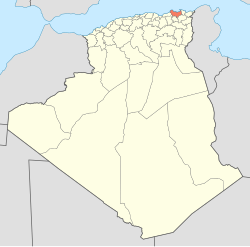
| Map of Algeria highlighting Skikda | |
| Coordinates: 36°52′N 6°54′ECoordinates: 36°52′N 6°54′E | |
| Country | |
| Capital | Skikda |
| Government | |
| • PPA president | |
| • Wāli | |
| Area | |
| • Total | 4,026 km2 (1,554 sq mi) |
| Population (2008)[1] | |
| • Total | 904,195 |
| • Density | 220/km2 (580/sq mi) |
| Time zone | CET (UTC+01) |
| Area Code | +213 (0) 38 |
| ISO 3166 code | DZ-21 |
| Districts | 13 |
| Municipalities | 38 |
Skikda or Sakīkdah (Arabic: سكيكدة ) is a city in north eastern Algeria and a port on the Gulf of Stora, the ancient Sinus Numidicus. It was known asPhilippeville until the end of theAlgerian War of Independence in 1962. It is the capital of Skikda Province andSkikda District.
History
modern city of Skikda was founded in 1838 by the French on the ruins of an ancient Phoenician city which later flourished as a large Roman city calledRusicade, a Punic word which means "Promontory of fire". In the 5th century, the Roman port was destroyed by the Vandals.
On October 10, 1883, there was an earthquake at Philippeville.[1]
Towards the end of World War II, there was a UNRRA refugee camp at Philippeville which was known as Camp Jeanne d'Arc. On January 25, 1945, 200 Jews holding citizenship from countries in North and South America were sent from the Bergen-Belsenconcentration camp to Switzerland as part of a prisoner exchange group. They were later sent to this UNRRA camp in Philippeville, Algeria.


No comments:
Post a Comment